I have read and heard about the natural beauty of Lofoten in the north of Norway. Beautiful scenery and quaint fishing villages as well as a beautiful road snaking itself between the islands of Lofoten over bridges and trough tunnels.
I am currently residing in the Åre vicinity in Sweden. I packed my Yamaha Tenere 700 with clothes and stuff such as tent, sleeping bag and air mattress, I only plan to use these in an emergency where I can’t find any accommodation. The distance to the ferry to Lofoten is around 700km so after some trepidation I set off.
I decided I could not go the whole way to Lofoten in one day so the first day I would go to Mosjöen, a distance of around 400km.

The first 55 kms goes through Sweden via Skalstugan on a nice flowing and twisty road with beautiful views over the nearby mountains, before going into Norway through a narrow valley towards the Trondheim Fjord. On the Norwegian side I stopped at a narrow bridge crossing the river and walked across. It turns out this path leads to defense fortifications that were built to defend against the Swedes in 1905 at the Sweden-Norway union dissolution. It’s a convoluted history going back to 1814 when Norway came into a union with Sweden after Denmark was forced to “give” Norway to Sweden as a result of Denmark being on the loosing side in the Napoleonic wars. Before 1814 Norway had been a part of Denmark for hundreds of years. In 1905 the Norwegian “storting” (parliament) decided to dissolve the union with Sweden and Sweden did not fight the issue and Norway became an independent country.

As I get closer to the fjord the landscape opens up and there are a lot of green fields and smell of farm as I ride past farm houses – nice! Once down by sea level the road connects to the E6 and I turn north. The E6 is the north-south artery of Norway, stretching through the country from the Swedish border in the south to the Russian border in the far north east, with a total length through the country of 2628km! I pass through the town of Steinkjer and a bit further north I stop at a pretty rest-place for lunch. I had packed some sandwiches and filled a bottle of water that work nicely to fill me up for the rest of the day.
As I’m having my lunch I strike up a conversation with a German biker and it turns out he is also going to Lofoten and that is as far north he is going.

Lunch by the E6
I continue to Mosjöen and reach the town around 5 pm. I have booked a room in a dog pension that got good reviews and was reasonably priced. I hadn’t checked the location of the pension carefully and it turns out it is 25km from the town. The road to the accommodation is taking me along the main road to Sandnessjöen along the north side of a fjord and I turn off up towards a hill along a gravel road and as I turn in to the property I see 4 other bikes parked along the building and I know I’m at the right place. Later on there are a few rooms taken by people with dogs but the dogs are well behaved and not allowed in the common rooms.

Motorcycle pension
I find in general there are a lot of bikers on the roads in Norway. Adventure biking has really taken off big time and a lot of the bikes are BMW GS models. Kudos to BMW for making a good bike and marketing it well.
The following day I get away at 9 am and am soon back on the E6, after a while I stop when I see a sign for sight seeing. The site in question is of two old vault bridges built of local rocks in 1926, beautifully built with a wild stream running beneath. These were the last bridges built with this method in Norway, later bridges were built using concrete and/or steel. The views over the fjord and mountain are breathtaking and I can’t get enough of the view.

Waulted bridge

Fjord views
The first town I hit is Mo i Rana where I stop for petrol and some chain TLC, as I’m doing this, a group of motorcycles arrive and I start talking with a biker, they are all from Vietnam and has joined a tour that provides bikes and a guide and are on their way to Nordkapp. Interesting!
I’m soon on my way and after a while I arrive at the polar-circle center located (yeah, you guessed it!) on the polar circle. I meet the German biker I met at lunch the previous day and we decide to ride together towards Lofoten.

Polar circle

Bikes at polar circle
As we go further north we go on the south side of the Skjerstad fjord instead of the faster north side via Fauske. The south side road is more motorcycle friendly with twisty mountainous passes and not much traffic, it turns out there are a lot of sheep on the road as well making for an interesting passage.

Sheep
At the end we get on “riksvei 17”, the scenic road from Steinkjer to Bodö, and we pass a magnificent bridge over Saltstraumen. Saltstraumen is the narrow inlet to the fjord and as the tidal state changes there are very strong currents, hence the name, “straum” means current in Norwegian.
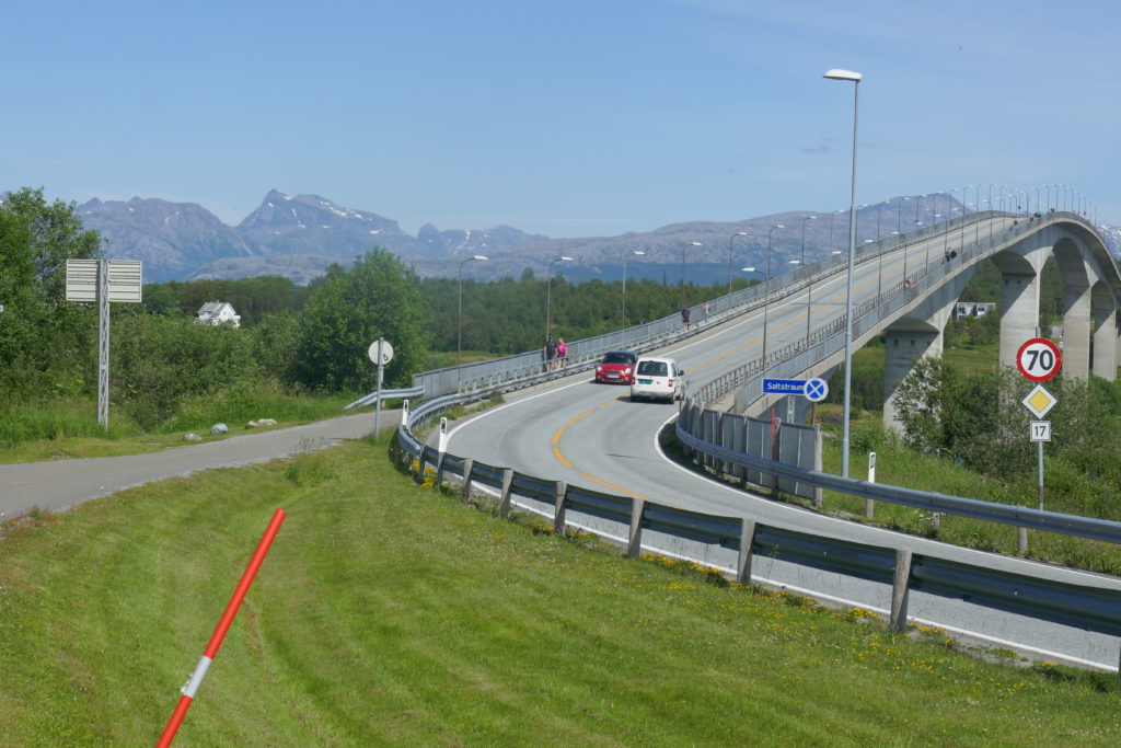
Saltstraumen bridge
We decide to try and reach the next ferry from Bodö to Moskenes on Lofoten. We reach the port 15 minutes before the ferry is sailing and after paying the ticket we are waved onboard.

Leaving Bodö behind
We’re concerned it might be challenging to find accommodation on Lofoten, it being a very popular tourist destination in the summer. Michael, my German biker friend, gets on the phone and finds accomodation around 70 km from the ferry port. It seems like quite a long way but the landlady assures us that it won’t be a problem, we should take it slowly and admire the views as we go along.
As we get closer to Lofoten and view the jagged coast-line and mountains for the first time, I can feel the anticipation growing, there are a lot of people standing with views of the islands and I can almost hear their gasps at the amazing views!

First views of Lofoten
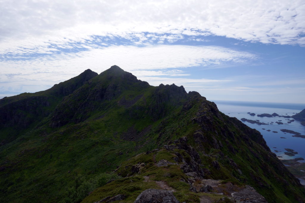
The ferry ride is between 3 and 4 hours so we have time for food and a nap before arriving in Moskenes. We don’t go directly towards the accomodation but go the other way to a place with the short and sweet name “Å” which is close to as far south you can go on Lofoten.

View from Å

View from Å
We turn north and start our trek to our accomodation, Anne Gerd’s guesthouse. We pass through quaint fishing villages, narrow single lane bridges and tunnels as the road winds it’s way across the islands.


Fishing village
It takes a couple of hours with all the stops for photo opportunities, but we finally reach Anne Gerd’s guest house around 9 pm. It’s been a long day and I’m pretty knackered so after a quick shower I hit the sack. The day’s route:

The following day, after a good night’s sleep, Anne Gerd, the landlady, insists that we hike up to higher ground to get the postcard view of Lofoten. With her convincing we decide to stay another day and Anne Gerd drives us to the trail head where she declares the hike to be an easy one. It turns out it’s not so easy, very rocky and steep, but we manage to hike up to an altitude of 350 meters. On the way we pass a ski lift with an adjacent alpine hill with light-posts, it starts at sea-level and ends at around 350 m above sea-level so quite a nice steep hill. Later I hear that it’s not every year there is enough snow for skiing. We continue to go higher and we must admit our landlady was right – the views are really quite amazing!

Stamsund hill towards Sennesvik

Stamsund hill towards north-west

Stamsund hill towards Stamsund
Stamsund hill towards south
In the evening we rode to a small quay side restaurant in the Sennesvik village. We were told the whale beef was so tender it was like biting into butter, Ok – it wasn’t that tender but very nice!

Whale meat for dinner
The day after the hike we start the trip back south, the weather is not so nice with light rain, fog, temperature around 10C and wet roads.

Gloomy start of the return trip

Single lane bridge to Hennigsvaer
We first stop to explore the Hennigsvaer football pitch shoehorned in between cliffs on a small island. And it’s not a cheap installation with artificial grass. Quite amazing!

Hennigsvaer

Hennigsvaer football pitch
The plan is to take the ferry from Lödingen to Bogenes on the main land and take the E6 south. The ride to the ferry goes without problems and we literally reach the ferry just as it is about to leave. As we board the bow visor is shut and the propellers start to spin. It is a short ferry ride and we’re soon on the mainland and ride south and as we reach Fauske we stop for the night.

Anne Gerd’s to Fauske
We stay the night in a motel at Lundhögda camping, it is a small room but with shower and toilet and a comfortable bed – who needs more? I wake up early next morning and have some leftover pizza from previous night’s dinner for breakfast before we set off south. My plan is to get “home” doing close to 700 km. At the junction of E6 and the road to Sweden in Verdal, Michael carries on a bit further while I do the last 100 km to reach Åre…

Last day trip

Home Sweet home
Nice picture and good article to read:-)
Tack för en både trevlig och informativ text och fantastiska foton. Så hisnande skön natur!
Anna
Enjoyed your trip report. Beautiful place for biking 🙂
Thanks for recounting the trip and the great photos. Almost feels like I was there! Amazing scenery.